


Forest professionals work in some of the most demanding environments where reliable equipment and accurate location data are essential for successful field operations. Whether crews are conducting timber inventories, mapping boundaries, documenting road conditions, monitoring forest health, or assessing wildfire damage, having dependable tools that simplify field data collection make a big difference in efficiency and accuracy. Juniper Systems’ Archer 4 paired with the GNSS Expansion Pod provides forestry teams with a rugged and flexible solution for capturing accurate location data in challenging environments. When combined with ArcGIS QuickCapture, Esri’s GIS data collection app for simplifying and accelerating field data capture, forestry crews can streamline workflows and improve the speed and consistency of field data collection.
Why Pair Archer 4 with ArcGIS QuickCapture?
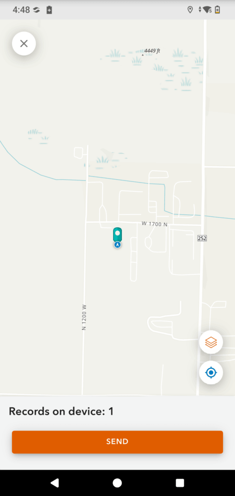
Forestry operations often require crews to move through remote terrain while documenting observations and capturing location data. The Archer 4 is built for these harsh conditions with its rugged MIL-STD-810H and IP68 rating, all-day battery life with hot-swappable capability, and a sunlight-readable display, crews can work through rain, dust, heat, cold, and anything else they find themselves in. Adding the GNSS Expansion Pod enhances the Archer 4 by providing RTK-level accuracy that helps forestry professionals confidently capture the location of observations and assets in the field. By combining data collector and receiver in one hand, users have another hand free to navigate uneven terrain or carry other items.
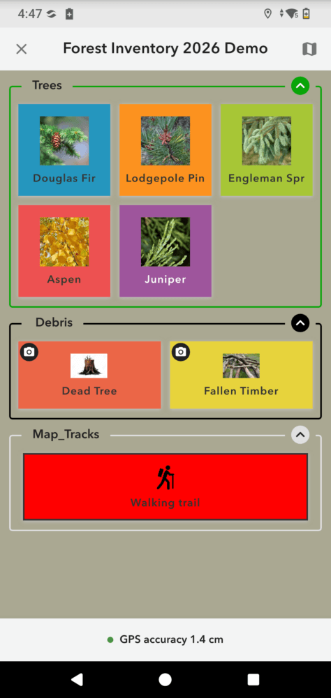
QuickCapture complements Archer 4’s capability by providing a fast and simple interface for data collection. Designed for rapid data collection, QuickCapture allows forestry crews to record observations with a single tap. Users can quickly document points, lines, and polygons while automatically recording GPS coordinates, timestamps, photos, and other important field information. This streamlined workflow helps reduce manual data entry and enables crews to stay focused on the task at hand rather than navigating complex forms or systems. Together, Archer 4 with the GNSS Expansion Pod and ArcGIS QuickCapture create a reliable solution for forestry professionals who need accurate data collection without added complexity.

Archer 4 and QuickCapture for Forestry Operations
Forestry professionals rely on efficient workflows and accurate field data to support day-to-day operations, especially when crews are working in remote and challenging environments. Pairing Archer 4 with the GNSS Expansion Pod and QuickCapture creates a streamlined solution that allows foresters to quickly capture accurate location data while staying focused on their work. Together, these tools help crews document timber inventory data, map trails and boundaries, inspect roads, monitor forest health, assess wildfire damage, track invasive species, identify hazard trees, and support reforestation efforts with greater efficiency and accuracy.
The rugged design of the Archer 4 allows crews to confidently operate in harsh conditions where devices are exposed to moisture, mud, impacts, dust, and extreme temperatures while the GNSS Expansion Pod enhances the accuracy of location data while moving through dense canopy or rugged terrain. ArcGIS QuickCapture complements this workflow by providing a simple and fast data collection interface with large, customizable buttons that make it easy for users to rapidly record observations, photos, and GPS locations while working in the field. Since QuickCapture supports offline workflows, users can continue collecting information in remote environments without cellular coverage and sync their data once connectivity becomes available. By combining rugged hardware, RTK-level positioning, and rapid GIS data collection, the Archer 4 with the GNSS Expansion Pod and QuickCapture help forestry professionals improve productivity, reduce time spent navigating forms or manually entering data, and maintain reliable and accurate records all while simplifying their workflows.
Juniper Systems and Esri: Supporting Modern Forestry Operations
Accurate field data is critical for making better forestry management decisions. Pairing Juniper Systems’ Archer 4 with the GNSS Expansion Pod and Esri’s QuickCapture app provides forestry professionals with a dependable and efficient solution for collecting location data in the field. The Archer 4 delivers the rugged reliability needed for demanding environments and the GNSS Expansion Pod provides RTK-level accuracy, while QuickCapture enables forestry crews to rapidly document field observations and synchronize data right into their existing workflows. Whether monitoring forest health, inspections, assessing wildfire damage or conducting reforestation efforts, the Archer 4 with the GNSS Expansion Pod and ArcGIS QuickCapture help foresters improve efficiency, accuracy, and reliability across their field operations.