


When Melissa Lenczewski, PhD, a professor in the Earth Atmosphere and Environment Department at Northern Illinois University, set off on a recent research trip to the Yucatan Peninsula in Mexico, she brought along a group of undergraduate students eager to learn and explore. Their mission? To investigate water quality and resources in the region, specifically focusing on groundwater flow and the unique challenges posed by the area’s sinkholes, or cenotes. Alongside them, they brought a key tool for their fieldwork: the Juniper Systems’ Geode™ GNS3 GNSS Receiver, a device that would play a critical role in the project’s success.
Choosing the Right Tool
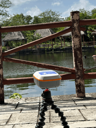
When Melissa began considering which GNSS receiver to use for her project, she remembered meeting the Juniper Systems’ team at a few conferences. The team explained how the Geode receiver is well-suited for navigating forested areas. She connected with Brian Mickel from Loggerhead Navigation, a dealer of Juniper Systems products, and decided to rent the Geode through him. Brian was incredibly helpful, guiding her through the options and recommending the Geode as the best unit for her project’s needs. Melissa said that Brian assured her, saying, “This is going to be the best unit for you; this is what you want.” His insights were invaluable, helping her focus on the right unit and make an informed decision. Melissa, who had limited experience with other GNSS receivers, found the Geode much more straightforward than the competitor’s device she had previously used, reinforcing her confidence in this choice. She goes on to share about the importance of the Geode’s portability, saying “our big thing was portability because we have to carry all of our gear down to Mexico. We needed something that was lightweight, small, and very compact, so we didn’t want something that was really large and took up a lot of our space.”

Understanding Water Flow and Quality
The primary goal of the trip was to provide undergraduate students with hands-on research experience. The team conducted two key projects involving the Geode. The first aimed to understand groundwater flow velocities within the sinkholes, while the second focused on monitoring groundwater recharge rates following a hurricane. “We needed to know the elevation and location of all our measurements,” Melissa explained. “With a coastal aquifer flowing north and another underlying aquifer, determining which sinkholes were part of which flow regimes was crucial for our groundwater flow modeling.”
During their fieldwork, the team faced an unexpected obstacle—a hurricane that swept through the Yucatan Peninsula, adding a new dimension to their study. The rainwater from the hurricane provided a unique opportunity to observe how sinkholes respond to extreme weather events, helping them understand the rate of groundwater recharge into the aquifer. “As the rain came in from the hurricane, it would go through the karst, and we were looking at the sinkholes as the water levels changed and determining recharge rates of groundwater into the aquifer,” Melissa explained.
Teaching Students to Use the Geode
Melissa emphasized that a significant aspect of the trip involved teaching students to use the Geode effectively. They needed a device that was easy to learn and use, given that they were undergraduates without extensive GIS experience. “The students could pick it up really quickly and be able to run the system extremely easy,” says Melissa. The Geode’s user-friendly design and the accompanying app made it straightforward for the students to record and manage data, which enabled smooth fieldwork.
“One of the big things that happened was realizing the impact of tree cover and satellite distribution in different regions,” she noted. The students learned how factors like tree density and geographic location can affect the Geode’s ability to acquire accurate measurements. The experience opened the students’ eyes to the differences between satellite systems in various countries and how these differences impact data collection. “It was really great to see the students learning about different satellite systems and thinking critically about why certain differences exist,” Melissa shared.
Unexpected Challenges in the Field
Despite the overall success of the trip, the team faced a few challenges. The hurricane, while a valuable learning experience, brought unpredictable weather conditions that kept the team indoors. Melissa explains that the hurricane didn’t stop them from gathering data; “We were on the outer edge of the hurricane, so it wasn’t crazy weather, just a lot of rain and wind. We put [the Geode] out at the beginning of the hurricane, and it worked great, so it wasn’t a problem.” The thick tree coverage also created difficulties for the team. “We couldn’t get measurements for sinkholes that didn’t have sky exposure,” Melissa explained. However, even in dense foliage, the Geode managed to capture accurate data by patiently waiting for satellite connections to stabilize. “The Geode could still get a signal in the tree coverage, but it just took longer, and we would have to stay in the same spot for several minutes, until the data’s variability stabilized,” said Melissa.
There were no technical issues with the Geode itself. However, Melissa mentioned the importance of reminding the students to keep the equipment charged and ready for use each day. “This was a critical part of ensuring the data collection process went smoothly,” she added. On occasion the students would forget to charge the Geode over-night, but it wasn’t a big issue and simply added to the student’s learning experience for properly maintaining equipment.


Data Integration and Workflow
Integrating the data collected by the Geode into the project workflow was seamless and efficient. The team utilized the Geode app on their phones to record essential details, such as the date, time, and location of all their observations. This capability significantly enhanced their ability to correlate various data points and ensure accuracy in their findings. “All we needed was the Geode and our phones,” Melissa said, highlighting the device’s simplicity and efficiency. The integration process allowed for smooth data handling and quick analysis, which was crucial in maintaining the project’s momentum.
Impact on the Research and Future Plans
Working with the local Yucatan Scientific Research Center (CICY), was a crucial aspect of the project. Collaborating closely with CICY, the team planned their sampling locations and shared their data. This partnership ensured that the findings would be integrated into a broader context, enhancing local knowledge and contributing to future research on water management.
The data collected using the Geode had a significant impact on the project’s outcomes. “Without the Geode, we wouldn’t have been able to accurately plot the locations for our other pieces of equipment,” Melissa stated. The device provided essential data on location, water velocity, and elevation, which was critical for analyzing groundwater flow and quality. Notably, the findings revealed concerning levels of microplastics and sunscreen chemicals in the water, especially after the hurricane. These results have prompted discussions with the Yucatan Scientific Research Center about potential water filtration improvements in the region.
A Memorable Experience for All
For Melissa, the most rewarding aspect of the trip was watching her students grow and learn. One of her favorite moments involved the students figuring out how to attach the Geode to a boogie board to keep it afloat while gathering data. “It was just really cute how they had the whole thing set up,” she recalled.
Overall, the trip provided an invaluable experience for the undergraduates, allowing them to apply their classroom knowledge in a real-world setting while learning to adapt to new challenges. As Melissa reflected on her favorite highlight of the research project, she said, “Knowing how easy it is using the Geode for the data collection made the process less complicated for the research and made it a very easy way to do it all.”
The Yucatan Peninsula trip was more than just a field research experience; it was a transformative journey of learning, discovery, and collaboration. Thanks to the Geode, the team could navigate through challenges and gather crucial data, setting a strong foundation for future research endeavors in water resource management.