

")
Before launching a new product, extensive internal and external testing must be done to ensure it meets or exceeds performance expectations. Part of Juniper Systems’ process is to use beta testers who put the product through real-world conditions to see if it will endure austere environments and still perform as intended. With our newest GNSS receiver, Spire, we were able to exceed performance expectations and bring a field-ready solution to market with the help of our trusted partners who put Spire to the test. Let’s get into who the testers are, the conditions they operated in, and how their feedback made Spire what it is.
Trusted Beta Testers
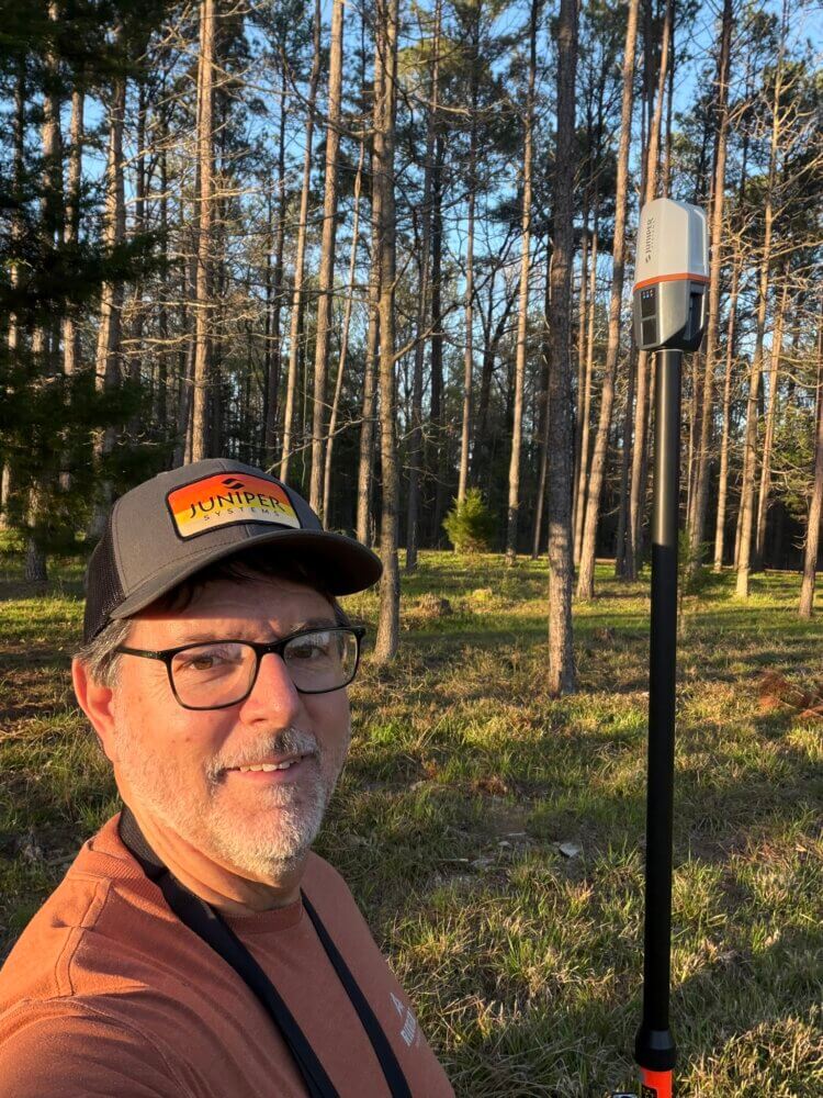
To see what it is was like to beta test Spire, we interviewed Johnny Thompson, the president of LandMark Spatial Solutions, and Noah Flick, a GIS and Mapping Hardware Representative with Frontier Precision. Johnny has been operating his forest technology company for 25 years, helping foresters embrace technology for forest inventory, forest measurement, drones, tablets, devices, and GPS, so their operations can be successful navigating and collecting data. Noah also has a great understanding of geospatial operations thanks to his degree in GIS development and his extensive work with data that comes from GNSS receivers and back-end automation of GIS.
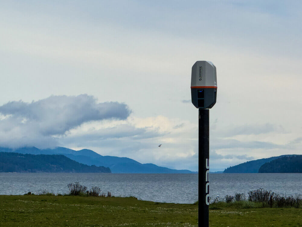
In addition to their expertise, where they tested Spire is just as important to ensure the conditions are challenging for the receiver and to measure its capabilities. Johnny being in the hot, humid, and dense canopy of Mississippi and Noah being in Washington state with its vast environments of cold mountain ranges, wet coastal fronts, and thick evergreen forests, provide great conditions and variety of elements to put Spire to the test.

First Impressions
Before getting into the details on how they tested Spire, we wanted to know their first impressions. Johnny said, “It was fantastic!” He also mentioned that he is working on making a video to post on LinkedIn showing how they do GPS testing with Spire. He noted that Spire has a series of beeps to indicate different things, such as powering on/off and achieving a correction service and that he liked that feature, since it’s not common for receivers to do that.
Noah said, “I was shocked by how light it was! I carried it in my backpack for a long time and I didn’t notice it.” He goes on to say, “I really liked the form factor, shape, and size. Overall, I expected it to work basically like the Geode, but in a new design.”
How they Tested Spire
Getting into how they tested Spire, Johnny explained that he has many ground control points surveyed under thick canopy along his property where he can track and record the accuracy of units for comparison. When asked how Spire performed on his course, Johnny said, “It did really well compared to the Geode, which is what we’ve known and trusted for years. So, the Spire compared to the Geode was very comparable and was even better than the Geode in a lot of places, going head-to-head on my test course.” He goes on to say that it wasn’t about how he felt about it, but that he could actually see the accuracy numbers with Uinta during testing. Sharing some of the data, he continues, “Without any corrections, Spire had about 2.5 to 2.6 feet of error across 14 positions and with my local NTRIP network it was only .3 feet of error across 14 positions under canopy. I was shocked! It actually beat the Geode, so it did a fantastic job!” He also mentioned that the Geode is a workhorse and that Spire isn’t meant to replace it, but that he’s impressed with its performance. During the conversation, Johnny talked about the accuracies forestry professionals had expected to get in the past and that they didn’t need high-accuracy solutions for clearing timber, but now they have the ability to get those precise positions: “It depends on what you’re trying to do, but forestry is different than urban GIS mapping or GPS mapping, where you want to have inch-level accuracy all the time, but in the forest we don’t have to be, but now we can be.”
With Noah being in the PNW, he said that the environment is “nasty for GPS” and getting the accuracies you need: “I live in the woods and most of the people that live here work in the woods, and GPS struggles here.” Continuing to talk about the area he tested it in and how it performed, Noah said, “It was good to get to take it out into the dense canopies, cold mountain environment, and the salt water, and just all of those wild place that our customers out here take them all the time; and so it worked great in our conditions.” While talking about RTK level accuracies he was able to get in the thick evergreens, he said he got the accuracy level you can expect while under dense canopy and that it was “well within reason.” He continues, “Obviously it’s going to be impacted, that’s just inherently part of the line-of-sight science, but it was sufficient in all categories.” While testing Spire in the Olympic National Park where he went into single digit temperatures in the snow covered mountains, the dense evergreens, and the ocean side, Noah said, “It was a great place to test it because I could test it in very wet conditions, I could test it in very cold conditions, and in very dense canopy.”

Feedback from Testing
When beta testing a product, it’s common for the testers to provide feedback on what they are doing with the unit and if they have any issues. This stage is crucial for ensuring that the receiver performs as designed and if any bugs or issues occur, that they are resolved before launch.
Both Johnny and Noah provided valuable feedback on Spire, how it performed, and if they ran into any issues. During their tests a few bugs were discovered, and they were reported to Juniper Systems product management, but they were worked out and resolved. As Noah said, “From a software bug standpoint, those finds were taken into account and were fixed.” Other than the bug fixes, neither one of them had any issues with the physical receiver during their testing.
Overall Thoughts
At the end of the interview, they were asked what they would tell someone that was considering Spire for field work. Johnny said this about Spire, “For forestry work, it’s a fantastic device. Whether you have corrections or not, if you have SBAS, you’re still going to get really good accuracy under canopy. It’s great value for the money, so it really is a solid device.” Asking Noah the same thing, he said, “I think it’s awesome. It’s the perfect entry level RTK receiver. The Geode still has its place, it still has a lot more features and capability with external sensors, so if you’re trying to do those more complicated projects, the Geode is still there. But for the user that’s just trying to get RTK accuracy and map some points, there’s really nothing better.”
Without Juniper Systems’ product development team, Spire wouldn’t exist. But equally as important, without the beta testers that put Spire to the test in a multitude of environments from across the country, Spire wouldn’t be what it is. Thanks to everyone involved, Spire can be anyone’s receiver – from the novice to the professional, they know they can depend on this lightweight and rugged solution to provide their Location, Simplified.