
Hyde Park City public works director Mike Grunig has the city a little worried.
“I’m thinking about retirement and they’re panicking,” Grunig said.
Grunig is a tenured public servant to the quiet Utah community, a mix of quaint single-family homes and scattered fields, with around 4,500 people inside its 3.4-mile city boundary. He is the guy who knows the location of everything.
Hyde Park City has old maps that it uses to track subsurface utility infrastructure, but mostly, Grunig said, “it’s all in my head.”
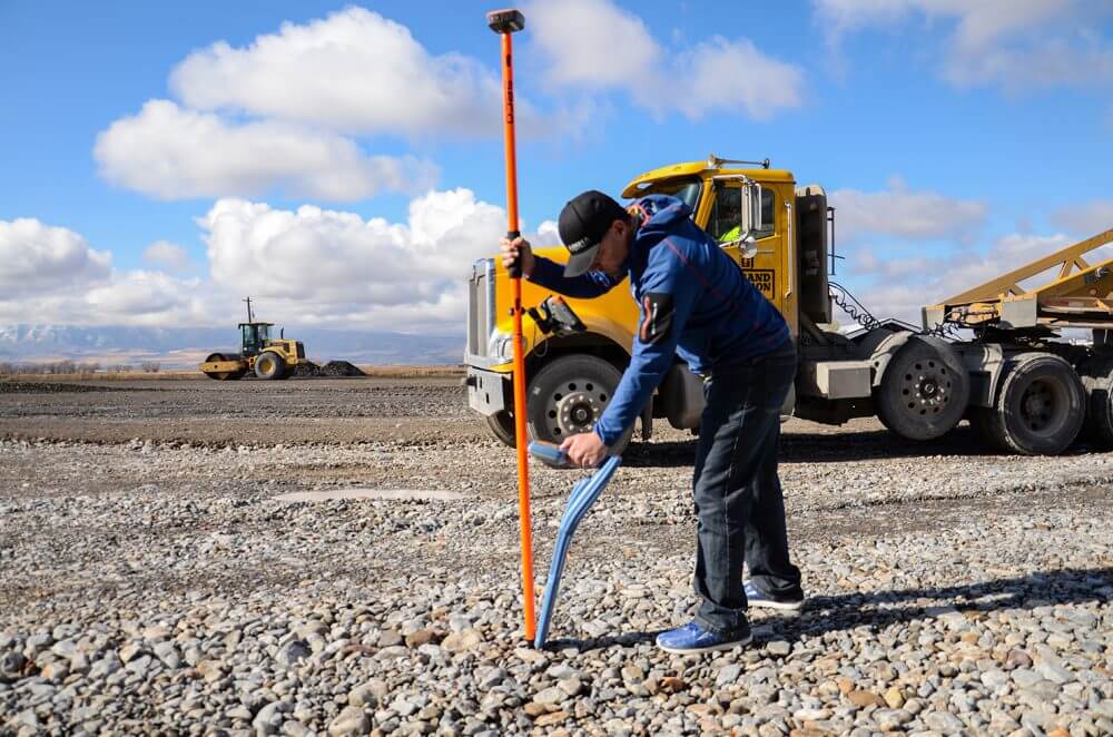
In late 2018, with support from City Council member Charles Wheeler, the city purchased a Geode Sub-meter GPS receiver. “Public works has been very pleased with us,” Wheeler said. “They are mapping our entire city in lots of ways.”
Hyde Park City uses the technology to map sprinklers, valves, manholes, and water features spread around the community, which incorporated in 1892.
“The political perspective,” he said, “is it’s been a successful and worthwhile investment.”
Accurate subsurface utility mapping is cropping up in small municipalities across the United States as GIS technology becomes affordable and easy to use. The trend comes at a time when infrastructure – like roads, water, and sewer systems – are a top concern for mayors of cities with populations of fewer than 50,000 people, according to an analysis by the National League of Cities.
The United States’ vast network of infrastructure is aged and in need of repairs and this technology is making crucial infrastructure data accessible to cities like Hyde Park City in Utah and Sandusky in Ohio.
“We’re a small city so investment in GIS technology is not a top priority,” said Tiffany Taylor, the Sandusky GIS analyst. “Because of the affordable receiver, and other similar technologies, this work becomes a reality for small municipalities.”
Before Sandusky had 15 Geode receivers and a bundle of Android tablets, subsurface infrastructure location data was tracked with a mix of Excel sheets and engineering drawings, which are located in a big back room. Now the city of around 24,000 makes the technology part of its daily routine.
Public works crews use Collector and Survey123 by ESRI on its tablets to locate infrastructure they see or know by memory. Construction inspectors mark utilities at new projects across the city. And then Taylor gathers with veterans of the Sandusky Public Works department to mark infrastructure on city maps.
“It benefits the citizens and the guys working every single day,” Taylor said. “Updated maps help them be more efficient and they help the citizens. If workers know where things are they can do their jobs more quickly – whether the worker has been there for a month or 10 years – that’s where this really gets value.”
Taylor said that talks with other municipalities indicated that prior subsurface utility mapping costs were prohibitive. “A Geode and a tablet is just a couple thousand dollars; it’s less scary and they can see the value,” Taylor added.
Hyde Park City echoed the sentiment.
“Down the road, it will save us money,” Grunig said. “We won’t have to dig through the asphalt to find something. We won’t have to search through the snow.”
The descending cost of accurate subsurface utility mapping made it possible – and will be a boon to communities across the United States.
“The technology hasn’t been as good as it is now,” Grunig said. “It’s finally good enough to pinpoint infrastructure and it’s not going to be obsolete so fast.”
Now Hyde Park City doesn’t have to be so worried about his retirement.
“I believe all cities will do this,” Grunig said. “It will be part of the way they function because it’s so much better than the one guy who has it all in his head.”
For more information about the Geode Sub-meter GPS receiver or Juniper Systems lineup of rugged mobile computers and tablets, contact us here. Visit Juniper Systems online.