
What level of accuracy is available for GPS/GNSS receivers today?
When it comes to accuracy for GPS/GNSS receivers there are a variety of levels available. With so many choices and claims made, it can be a challenge for users to understand which receiver is best for the job at hand. To make things easier for users, Juniper Systems has created a simple to use guide for a better understanding of GPS/GNSS accuracy levels.
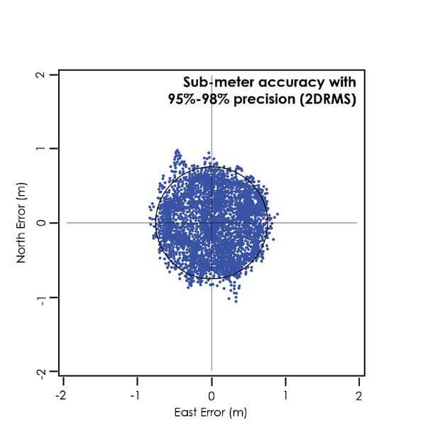
Let’s begin with introducing and defining some of the industry standards for defining GPS performance including Circular Error Probable (CEP), Root Mean Square (RMS), Two times the distance of RMS (2DRMS), and Radius 95% (R95). Each of these statistical measures have different levels of accuracy or confidence. For example, the statistical probability or confidence for CEP is 50%, RMS is 63-68%, 2DRMS is 95-98%, and R95 is 95% accuracy.
These levels of accuracy allow the user to be confident in their measurements, data, and mapping. For example, if a user had a GPS receiver with an accuracy of “submeter R95”, then the user could confidently say that with 95% accuracy the data collected can be found within a meter of the GPS coordinates.
The civilian GPS signal is designed to provide an accuracy of about 10 meters, or about 33 feet. There is also a military-specific signal, when used with specific receivers, that is capable of an accuracy of about two meters. When considered as a worldwide system, this is a very accurate position. However, much greater accuracy is achievable when sources of error can be taken into consideration and removed from position calculations. Depending on the technology and techniques used, accuracies of less than a meter, a foot, a decimeter, and even a centimeter are achievable. For users looking for professional positioning systems, the most common ranges for accuracy include sub-meter, sub-foot, and centimeter.
When purchasing a GPS receiver, users will want to be aware that GPS accuracy is a combination of technology and technique. This means that for users to get accuracy to the centimeter level, the device will need to have some of the best technology available. In addition to this, users will want to be aware of the environments the receiver will be used in to determine the technology required.
How can the accuracy and precision of my GPS receiver make my job easier?
For many field workers collecting data for irrigation, forestry, or any other service, Juniper Systems is here to help users understand what they can gain from the various levels of precision a GPS receiver offers. Here are three ways a GPS receiver can make a user’s job easier with precision and accuracy:
- Save time.
Whether users are recording assets, wildlife surveys or meter installations GPS can improve the efficiencies of any job. When users take full advantage of a GPS receiver, the recording, mapping, and asset management will become easier than ever. - Stay within your budget.
When users can identify the level of exactness required for the job at hand, users can avoid the trap of overpaying for GPS receivers. To put this into perspective for professionals in the field, purchasing a device that meets the needs of the job can greatly impact the amount of time needed for workers to collect, evaluate, and revisit sites. For example, users in the irrigation segment typically require a GPS receiver that ranges from sub-meter accuracy to decimeter levels of exactness. By having any of these features, users are able to identify issues, shorten lead times for customers effected by the equipment mapped, and return to specific sites that are of value to the company. This can come in a variety of forms depending on the specific project being started, evaluated, or finalized. These forms include, but are not limited to the resolution of the data or mapping collected.
For more helpful information related to mapping and data collection on a budget, click here. - Record without error.
Precisely calculate the location of your work or data collection using the information from numerous GPS satellites. With the combination of technology and technique, users can utilize the atomic clocks onboard GNSS satellites to achieve extreme accuracy.
To achieve the highest accuracy possible, users should be aware of factors affecting GPS accuracy. There are five factors users should be aware of to achieve the best GPS position and data accuracy. These five factors affecting GPS precision include: getting a good GPS Ephemeris and Almanac on the receiver in use, setting up a good antenna mask angle, being aware of obstructions, utilizing supporting tools and equipment, and double-checking the settings of the device.

For a more in-depth look at these five best practices and more in achieving better GPS accuracy, click here.
What do users need to know about GPS accuracy claims before buying?
When it comes to GPS accuracy claims, users need to know that there are three main areas to understand before purchasing a GPS receiver. Geospatial expert John Florio recommends looking at price, accuracy, and work environment.
The first area of focus is price. Quite frequently Juniper Systems hears users express the necessity to stay within a certain budget. It is crucial for users to stay within budget, while getting the level of accuracy necessary for the mapping or data collection done. For example, the price difference between the professional-grade Geode™ Sub-meter GPS Receiver and consumer-grade devices is about a 3x to 4x multiplier. While that sounds significant, this is comparable to the relative accuracy of the data captured.
Imagine locating a well or buried valve with devices of different accuracy. Where one tool might require three or four “scoops” of a backhoe, a more accurate solution might achieve the work in a single try. Perform this same work multiple times and the cost savings quickly becomes apparent. This means users will need to look beyond the price and take a closer look at the details of the device. Some details to look at include: the grade of the device (professional or consumer), the standard the company uses to determine accuracy, application, and operating system versatility.
Florio recommends that once price and budget are determined, that accuracy is the very next element of the GPS receiver to consider. There are four frequently used statistical values commonly used to describe the accuracy of a GPS receiver. They include Circular Error Probable (CEP), Root Mean Square (RMS), Two times the distance of RMS (2DRMS), and Radius 95% (R95). Each of these statistical measures has different levels of accuracy or confidence. For example, the statistical probability or confidence for CEP is 50%, RMS is 63-68%, 2DRMS is 95-98%, and R95 is 95% accuracy.
|
Term |
Definition |
Accuracy / Probability / Confidence |
|---|---|---|
|
CEP |
Circular Error Probable |
50% |
|
RMS |
Root Mean Square |
63–68% |
|
2DRMS |
Two times the distance of RMS |
95–98% |
|
R95 |
Radius 95% |
95% |
This means that if a user purchases a device with sub-meter accuracy and a CEP confidence level, the data collected is within 2 meters 50% of the time. While that sounds alright, remember that about 50% or half of the captured data points will be outside of this accuracy estimate.

Users need to consider what is the “least acceptable” answer when considering GPS accuracy. For some users, this is exactly what is needed and within the budget. However, if unsure of the needs and accuracy level required to map assets, irrigation, utilities, or something else, then we recommend asking two questions:
- What is the size of the object I am recording?
- Will I be returning to this site at different times of the year?
If the object being recorded is smaller than 3 feet in size, then a GPS receiver with sub-meter accuracy is an ideal choice for users. If this same object is being visited throughout multiple seasons, then the user will want to consider a GPS receiver with the reliability of 2DRMS or R95. The reason for this is for users to have greater confidence in quickly locating and identifying the object with minimal delays.
The final aspect to pay close attention to is the specific needs of the job at hand today and in the future. Whether users are in the desert, arctic regions, or a humid jungle the Geode real-time sub-meter GPS receiver can withstand all of these environments and more.
How close is close enough for the task at hand?
This question is often asked by users looking to understand how to stay within budget and still get the precision needed for the job to be completed. The most basic of GPS devices receive a signal that is designed to provide an accuracy of about 10 meters, or about 33 feet. Beyond the basic signal for GPS is the military-specific signal, when used with specific receivers, which is capable of accuracy of about two meters. Much greater accuracy is achievable when sources of error can be taken into consideration and applied to position calculations. Depending on the technology and techniques used, accuracies of less than a meter, or a foot, or a decimeter, even a centimeter of accuracy is achievable.
However, it is best to keep in mind that while a centimeter of accuracy is achievable, it is not always warranted or achievable with budget constraints. Therefore, users should consider what is being mapped, potential time constraints, and the standards of quality promised for the job to be done. By considering these three aspects of a GPS receiver, users can feel more confident in the purchase made.
What GPS device will give the most bang for a user’s buck?
The most “bang for your buck” is best understood as spending just enough money to efficiently and repeatedly accomplish the job that needs to be done today. Don’t under-buy, or settle for the lowest cost solution, as it will often provide the lowest quality results relative to the work to be done.
On the flip side of this advice, users shouldn’t over-buy; don’t budget for some future project or extreme challenge that isn’t typical of day-to-day tasks. Simply start with the tools that will accomplish the job efficiently, reliably, and perform to standards that clients expect. When new opportunities arise, or new technologies come about that can increase efficiencies, then consider investing in those improvements.
When evaluating a GPS receiver or a GPS receiver provider, consider evaluating things like the quality and responsiveness of the organization, and how well they take an interest in understanding the needs of users. Users and purchasers of GPS receivers will want to evaluate the cost of the solution intended to be bought over time:
- Will it be the least expensive today, and possibly have a high risk of failure and require rapid replacement and additional expense?
- Will it have “all the bells and whistles”, including paying for features that may never be used?
- Will it be “scalable”, lasting long enough in the field to allow for upgrades and feature additions as needed as work requirements change?
Check with reputable references you know in your industry, as they can tell you what has worked well for them and made them successful. And as always, consider the cost as an investment in the quality of work you intend to deliver to the client.
Let’s Talk
Mapping and data collection with a GPS receiver can be a robust task to accomplish. Not to worry, our in-house experts on GIS mapping and data collection are happy to help. Should you have more questions or would like more information, please reach out by contacting our GPS experts here.